Tropical Storm Helene has officially formed, is rapidly intensifying, and is forecast to become a major Category 3 hurricane before making landfall in Florida on September 26, 2024. This offers an update you on the system’s status, impacts in Central Florida, Walt Disney World’s policies, and more.
The key thing to know is that it’s currently business as usual at Walt Disney World as of September 24 at 1 pm Eastern. The company has not announced any closures, cancellations, or operational impacts whatsoever due to Tropical Storm Helene. If you’re simply worried about what could be closing or changing at the resorts, water parks, restaurants, etc., the answer is nothing. So far.
With that said, Disney always monitors the weather and will prioritize guest and Cast Member safety above all else. It’s premature for any announcements about Walt Disney World operations. We’d expect that to happen on Tuesday, and only if it becomes clear that Helene will pose an actual threat–beyond just wet weather and wind–to Walt Disney World.
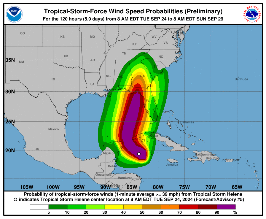
The National Weather Service on Tuesday issued inland tropical storm watches for most of Central Florida for what’s forecast to become major Category 3 Hurricane Helene as it approaches the state’s Gulf Coast, with those coastal counties all under a Hurricane Watch.
The Tropical Storm Watch includes Lake, Marion, Polk, Seminole, Sumter counties, as well as Orange, Osceola–the most notable counties for our purposes, as they’re where Walt Disney World is located. This means tropical-storm conditions are possible within 48 hours.
As of the latest update on September 24, 2024 from the National Hurricane Center, here are the key messages for Tropical Storm Helene…


The center of Tropical Storm Helene is moving toward the northwest near 12 mph (19 km/h), with a faster forward speed expected on Wednesday and Thursday. On the forecast track, the center of Helene will move across the far northwestern Caribbean Sea through tonight, and then move across the eastern Gulf of Mexico Wednesday and Thursday, potentially reaching the Gulf coast of Florida late Thursday.
Data from an Air Force Reserve Hurricane Hunter aircraft indicate that Helene has acquired a well-defined center of circulation,
and maximum sustained winds have increased to near 45 mph (75 km/h) with higher gusts. Additional strengthening is forecast, and
Helene is expected to become a hurricane on Wednesday. Continued strengthening is anticipated after that time, and Helene could become a major hurricane on Thursday before making landfall in Florida. Tropical-storm-force winds extend outward up to 140 miles (220 km) to the east of the center.
Over the Southeastern U.S., Helene is expected to produce total rain accumulations of 4 to 8 inches with isolated totals around 12
inches. This rainfall will likely result in areas of considerable flash and urban flooding, with minor to moderate river flooding
likely, and isolated major river flooding possible. The combination of a dangerous storm surge and the tide will cause normally dry areas near the coast to be flooded by rising waters moving inland from the shoreline.


Hurricane conditions are possible within the U.S. watch areas Wednesday night and early Thursday. Tropical storm conditions are expected in the warning area in the Lower Florida Keys beginning on Wednesday, and are possible in the watch area in the Middle Florida Keys beginning late Wednesday.
The storm’s center could target the Big Bend, similar to this year’s Hurricane Debby and last year’s Hurricane Idalia, but could also still shift to the east near Tampa or west to the middle of Florida’s Panhandle. The National Weather Service in Melbourne has stated that it’s too early to forecast a precise impacts for the Orlando area.
NHC Deputy Director Jaime Rhome indicated that the hazards are going to be well removed from Helene’s center and well removed from the cone, regardless of where in Florida the system makes landfall. He warns against looking at the cone of uncertainty because the wind field is going to be larger than with a traditional hurricane.


Florida Governor Ron DeSantis held a press conference from the State Emergency Operations Center in Tallahassee. The intensifying of Helene resulted in the governor expanding his earlier state of emergency declaration to 61 of Florida’s 67 counties, up from 41. The state of emergency now all Central Florida counties, including Osceola or Orange, which Walt Disney World calls home.
At a briefing in Tallahassee, DeSantis urged all Floridians to prepare for Helene to be dangerous, stating that the NHC never in its history had a forecast for a major hurricane for a system that had yet to even form (which was the case with Helene–but it’s since formed). Although the system is fast-approaching, DeSantis said Florida residents still have time Tuesday and early Wednesday to prepare, fill gas tanks, get water and nonperishable food, clean up yards for potential debris and know evacuation zones.
“We prepare for the worst, we hope for the best, but we’d rather be prepared and then have it not reach that level, than just hope that it doesn’t intensify and then be caught not being prepared,” DeSantis said. He explained that there are similarities to Hurricane Michael, which has a chance for rapid intensification as a result. “Right now, regardless of how it forms or the speed right now, you do have time, so take advantage of that time,” he added.
During the briefing DeSantis also elaborated on actions the state is taking, such as mobilizing the National Guard and preparing to deploy SpaceX Starlink internet if needed in impacted areas. Florida also has new flood protection devices primarily for use to protect utility substations. He also warned of power losses, but said there thousands of worker standing by at the major utility companies, preparing to restore power in the days after the storms pass.


The governor reiterated the importance of being vigilant, shared resources for reporting scams and price gouging, and implored Floridians to heed the warnings of local officials, as storm tracking is always fluid. DeSantis also urged Floridians to have seven days worth of supplies and to stay tuned to local media for the latest forecast updates, but not panic buy.
DeSantis also urged residents to listen to local evacuation orders, and avoid the tragedy seen in 2022’s Hurricane Ian that killed 149 people in Florida, most of whom were caught in major storm surge in southwest Florida. He said evacuation doesn’t have to be far, but they do need to get out from the danger zone.
“Most of the evacuations from the low lying areas, people do not need to even leave their county,” DeSantis said. He explained that the misconception about hurricanes is the wind is what’s most dangerous, “but the reality is that water…that’s tough. The wind you can hide from. Anything that’s shelter in Florida is going to be able to withstand the wind, but it’s the water that can be really, really devastating if you remain there when you’re told to evacuate.”
Florida Division of Emergency Management Director Kevin Guthrie said the state expanded its county disaster declaration because of the expected size of the storm. He explained that the hurricane will have tropical storm force winds in excess of 250 miles from the center that’ll encompass most of the peninsula from the Space Coast all the way to the west coast of Florida. He urged Floridians to prepare for the impacts of a major hurricane, and not to take the threat lightly.


As always, we’re not attempting to be alarmists. Anyone who has experienced storm season in Florida knows these forecasts can–and usually do–change. In the past few years, hurricanes originally forecast to miss Florida entirely have swerved towards the state and others with a high probability of wreaking havoc have weakened at the last minute.
We have witnessed this ourselves with Hurricanes Irma, Dorian, and Isaias. Hopefully, Tropical Storm Helene is like those rather than Hurricane Ian, and will drift west and have minimal impact on Central Florida as a result.
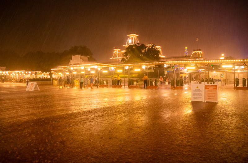
It’s always better to err on the side of caution and be prepared rather than not taking a major storm system seriously. Regardless of how models evolve, Tropical Storm Helene will bring heavier than normal precipitation and wind to Central Florida, meaning that–at best–it’s going to an even rainier week at Walt Disney World.
You’ll definitely want to keep an eye on this system if you’re currently planning to be in the parks this coming week. At minimum, come prepared for heavy rain, as Walt Disney World is now in the heart of tropical storm season!


Aside from the aforementioned wet and windy weather, the operational impact on Walt Disney World is still unknown. Again, Walt Disney World has not issued any closures or warnings.
Our hope is that Tropical Storm Helene won’t necessitate a closure of the Walt Disney World theme parks. It’s approaching the west coast, rather than the east coast, of Florida. Although it’s intensifying, it doesn’t have the same forecast strength as other storms from the last few years, and the current forecasts call for the worst impacts missing Orlando.
That probably means it’ll be mostly a matter of heavy rain and wind at Walt Disney World. But, and this probably goes without saying, you should get severe weather preparedness advice from sources other than a fan blog about Disney. As it concerns our actual area of expertise, we wouldn’t be surprised to see a relocation of guests from Fort Wilderness. (That’s usually the very first thing to happen.) But we wouldn’t be surprised if that’s the extent of the Tropical Storm Helene operational impact.


Since Walt Disney World has not yet issued any updates, its normal hurricane policy is in place. That takes effect when a hurricane warning is issued by the National Hurricane Center for the Orlando area or for the guest’s place of residence within 7 days before the scheduled arrival date of the storm. Although that has not happened yet, it’s incredibly common for Walt Disney World to accommodate guests and allow cancellations or changes without penalty even in the current circumstances.
This is at the discretion of phone representative with whom you speak, and outcomes can differ given the circumstances. As always, be kind to Cast Members, booking agents, travel agents, or anyone whose assistance you need. Remember, they do not control the weather. (Which seems like a silly thing to type, but you’d be surprised how many people seem to think that.) If the concept of kindness for its own sake is too much to grasp, just remember that (selfishly!) you can catch more flies with honey than with vinegar.
We’ll keep you posted with updates from the National Hurricane Center and operational updates from Walt Disney World if/when one is released. If you’re planning a visit, you can also consult our Tips for Hurricane & Storm Season at Walt Disney World for generalized advice on packing, avoiding the worst of the wet weather, and even riding out a hurricane. We hope and doubt it’ll come to that with Tropical Storm Helene!
Planning a Walt Disney World trip? Learn about hotels on our Walt Disney World Hotels Reviews page. For where to eat, read our Walt Disney World Restaurant Reviews. To save money on tickets or determine which type to buy, read our Tips for Saving Money on Walt Disney World Tickets post. Our What to Pack for Disney Trips post takes a unique look at clever items to take. For what to do and when to do it, our Walt Disney World Ride Guides will help. For comprehensive advice, the best place to start is our Walt Disney World Trip Planning Guide for everything you need to know!
YOUR THOUGHTS
Are you concerned that Tropical Storm Helene will impact Walt Disney World? Are you currently in Central Florida? Have you visited during past tropical storms or hurricanes? Any additional info, thoughts, or first-hand experiences to share about riding out a hurricane at Walt Disney World? Do you agree or disagree with our assessment? Any questions we can help you answer? Hearing your feedback–even when you disagree with us–is both interesting to us and helpful to other readers, so please share your thoughts below in the comments!


